
A view of Cedar Breaks National Monument
Cedar City is not very far from Cedar Breaks at all. You just get onto Utah route 14 and drive about 30 minutes east ... and one mile straight up.
Along the way there are some good views back towards Cedar City. Pretty soon you are at 10,000 feet and the air is remarkably cool -- and then there is the sign for SR56 and Cedar Breaks. When I parked at the headquarters (basically just a few little buildings, really) there was leftover hail on the ground, from the previous day.
Unlike Zion (a true canyon) but like Bryce `Canyon', Cedar Breaks is really an amphitheater -- a semi-circular cliff that falls away in a slope. In this case the slope is quite steep and the bottom is very far down. Unlike Bryce, there are no paths from the rim to the bottom. (It is possible to hike up to the bottom from the other direction, though.) The colors are the result of minerals in the rocks, and they change with the sunlight. I took 14 pictures, all from different points and at different times; rather than making one huge page with them all, I have broken them into several pages with several images each, based on the point from which I took them.
The last three are the sharpest -- I took them later in the afternoon, on the way back from Brian Head, and the sun was better.There is a short trail that leads to (and around) an alpine pond. If you go all the way around, and backtrack a bit like I did, it is a bit over 2 miles (maybe 3.5 km).
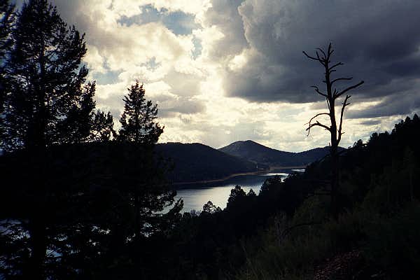
Just a little further down the road is Brian Head, a convenient high peak with amazing views.Leaving Brian Head and Cedar Breaks behind, I returned to SR14 and continued eastwards. In the late afternoon sun, between bursts of rain from the thunderclouds I had seen from Brian Head, I took a picture of Navajo Lake.
Eventually SR14 ends at US89. My original intent had been to turn north, go up to Bryce Canyon, and camp there for the night, but those thunderclouds were clearly headed that way. The path to the south was clear and bright, so I headed that way instead.
I stayed overnight in Page, AZ. This is where the Glen Canyon Dam holds back Lake Powell. I managed to forget my camera when I took the dam tour, though, so I have no pictures from there.